
KASPR Datahaus · use case
Which listed firms sat inside the January storm?
A blizzard crossed the central and eastern United States on 23–28 January 2026 (EM-DAT 2026-0026-USA). In the disaster-linked counties, KASPR measurement records which districts’ connectivity actually broke — and the company layer records which listed firms hold internet infrastructure inside them. Joining the two turns a weather map into an exposure list.
23 of 1023
districts broke, of those linked
360
listed firms with address space inside
23–28 Jan 2026
event window
−79%
deepest district shortfall
The join
Event, measurement, footprint
Three records intersect. The disaster record names the counties a storm touched. The measurement record narrows them to districts whose connectivity fell more than 20% below baseline for two or more days inside the window — the storm as infrastructure experienced it. The footprint record lists the listed companies holding IP address space in those districts, with tickers.
The narrowing is the point. This storm’s disaster record touches 1023 measured districts; 23 of them broke. An exposure screen built on the disaster record alone is 44 times too wide.
The districts
Where the storm reached the infrastructure
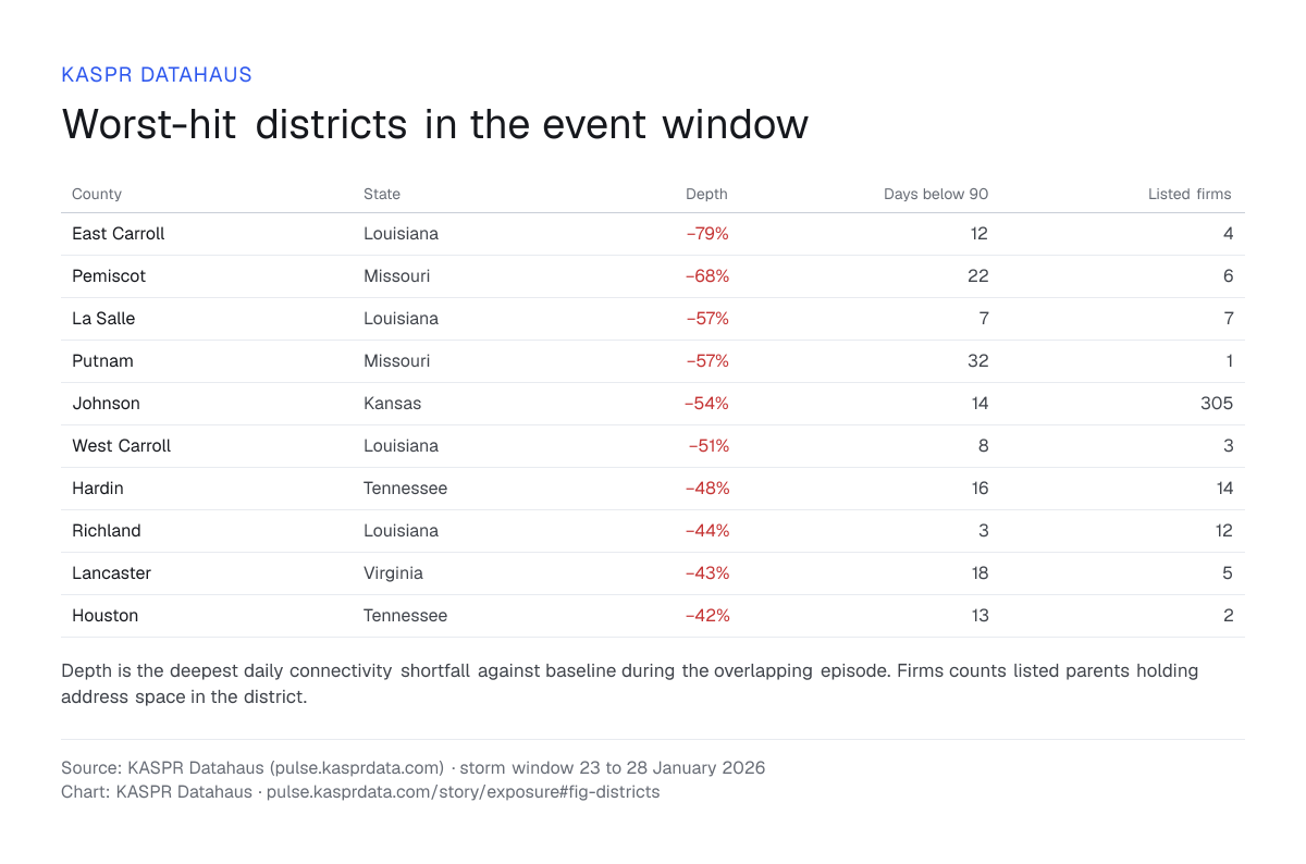
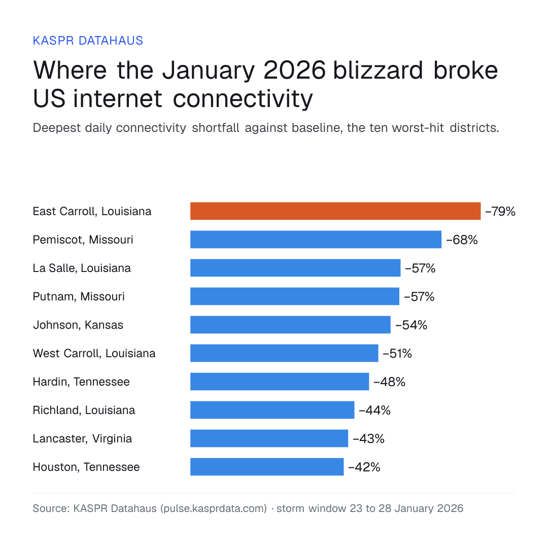
The districts below fell furthest. Several are rural parishes and counties that stayed degraded for a week or more after the storm passed; one — Johnson County, Kansas — is a major suburban county that carries address space for over three hundred listed firms.
| County | State | Depth | Days below 90 | Listed firms |
|---|---|---|---|---|
| East Carroll | Louisiana | −79% | 12 | 4 |
| Pemiscot | Missouri | −68% | 22 | 6 |
| La Salle | Louisiana | −57% | 7 | 7 |
| Putnam | Missouri | −57% | 32 | 1 |
| Johnson | Kansas | −54% | 14 | 305 |
| West Carroll | Louisiana | −51% | 8 | 3 |
| Hardin | Tennessee | −48% | 16 | 14 |
| Richland | Louisiana | −44% | 3 | 12 |
| Lancaster | Virginia | −43% | 18 | 5 |
| Houston | Tennessee | −42% | 13 | 2 |
The firms
The exposure list
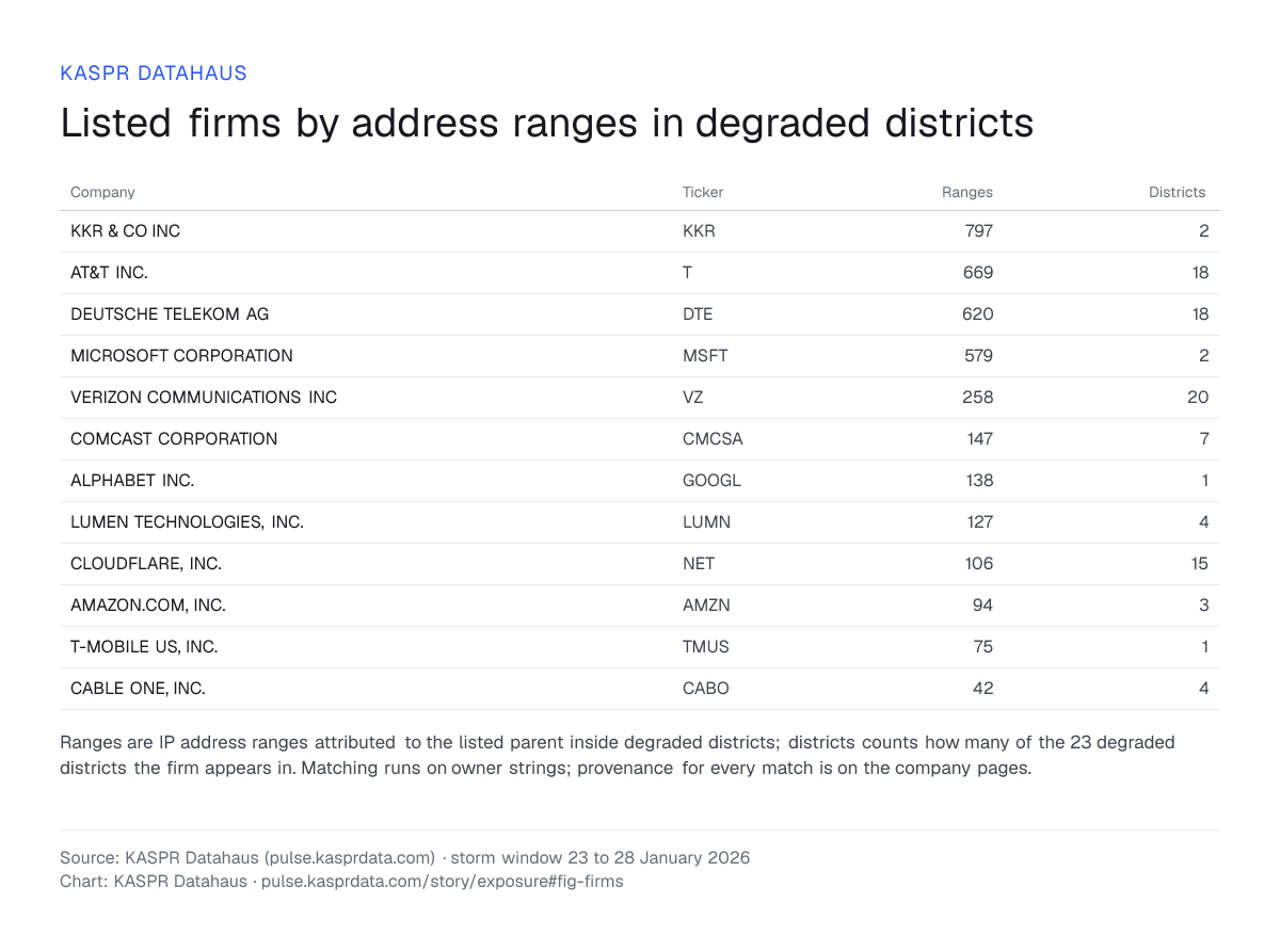
Listed parents ranked by address ranges inside the degraded districts. Telecoms dominate, as they should — their assets are the network — but the list runs through cloud, content and finance. Address space is presence, not damage: the list says who had infrastructure standing in a district that broke.
| Company | Ticker | Ranges | Districts |
|---|---|---|---|
| KKR & CO INC | KKR | 797 | 2 |
| AT&T INC. | T | 669 | 18 |
| DEUTSCHE TELEKOM AG | DTE | 620 | 18 |
| MICROSOFT CORPORATION | MSFT | 579 | 2 |
| VERIZON COMMUNICATIONS INC | VZ | 258 | 20 |
| COMCAST CORPORATION | CMCSA | 147 | 7 |
| ALPHABET INC. | GOOGL | 138 | 1 |
| LUMEN TECHNOLOGIES, INC. | LUMN | 127 | 4 |
| CLOUDFLARE, INC. | NET | 106 | 15 |
| AMAZON.COM, INC. | AMZN | 94 | 3 |
| T-MOBILE US, INC. | TMUS | 75 | 1 |
| CABLE ONE, INC. | CABO | 42 | 4 |
What this is for
Reading it as a portfolio
The same join runs for any event and any footprint, in either direction: from an event to the firms inside it within hours of the measurement window opening, or from a portfolio to the events its districts have recorded. Neither the disaster record nor a speed test can produce this list, because neither carries an object called a company.
Questions and answers
- Which US districts lost internet connectivity in the January 2026 blizzard?
- The disaster record links the blizzard of 23–28 Jan 2026 to 1,023 measured districts, and 23 of them broke: their connectivity fell more than 20% below baseline for two or more days. The deepest shortfall was −79%, in East Carroll, Louisiana.
- How many listed companies had infrastructure in the districts the storm broke?
- 360 listed companies held IP address space inside the 23 districts. Johnson County, Kansas, a large suburban county, carried address space for 305 of them.
- Why is a disaster record too wide for an exposure screen?
- Of the 1,023 districts the disaster record links to this storm, 23 broke, so a screen built on the disaster record alone is 44 times too wide. Measurement narrows the list to the districts whose connectivity fell.
How this was measured
The disaster record, EM-DAT 2026-0026-USA, names the counties the blizzard of 23 to 28 January 2026 touched. KASPR’s measurement keeps the districts whose daily connectivity fell more than 20% below baseline for two or more days, in an episode that overlaps the window from two days before the storm began to fourteen days after. Depth is the deepest daily shortfall against baseline in that episode. The company layer then lists the listed parents holding IP address space in those districts, matched on owner strings. Address space records presence: the list names the firms with infrastructure standing in a district that broke.